
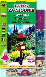
West Tatras (Tatry Zachodnie)
słowackie i polskie
scale
legend
size
1st edition
author
publishers
ISBN
1:25 000
6 languages
132 x 88 cm
2002
Michael Siwicki
978-83-87873-36-3 978-83-7499-012-7
distribution
![]()
A map of West Tatras in 1:25 000 scale is the continuation of series begun with the map of TNP. The main difference between our map and slovakian competitor is another extent, we show north part of the ridge with Zuberec, Zverovka and Osobita.
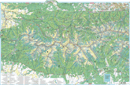
The explanation contains about 100 signs, described in 6 languages (PL, GB, D, SK, F, H). No one map has so much names. Vivid hill shading and rocks clearly show relief. There is geographical grid suitable for GPS here, pictures of plants and animals, time distances etc.
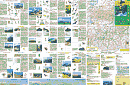
Directory on back side is very extensive. Besides geographical informations about the ridge you can find several notes about valleys and mountain huts, with photos and places for commemorative stamps. Access map, schema of touristic routes, coverage of mobile phones map, touristic directory and panoramas make the back side very interesting. There are photos of landscapes and pictures of plants and animals here too.
You can join this map with a sheet of High Tatras map.