
Slovak Paradise (Slovenský Raj, Słowacki Raj)
tourist map (mapa turystyczna)
scale
legend
size
1st edition
authors
publishers
ISBN
1:50 000
3 languages
44 x 40 cm
2003
Witold Czajka
Andrew Gogoc
978-83-7499-005-9

distribution
![]()
A map of Slovenský Raj in 1:50 000 scale shows one of the most beautiful regions of Slovakia. This is a small national park, so the map is small too.
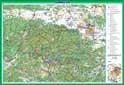
The explanation contains about 60 signs, described in 3 languages (PL, GB, SK). There are signed chains and ladders, time distances, one-way routes, mountain shelters and campings. Yuo can find names of bus stops and railway stops, as usually on our maps. Colourfull small pictorials of plants and animals facilities make it even more attractive.
On back side you can find several informations about the national park and objects worth seeing. There is a small map there showing how to get to the park.