
Pieniny National Park (Pieniński Park Narodowy)
Polish and Slovakian Pieniny (Pieniny polskie i słowackie)
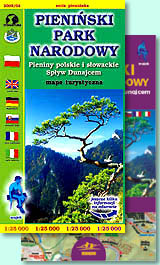
scale
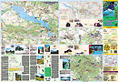
legend
size
1st edition
author
publishers
ISBN
1:25 000
6 languages
97 x 67 cm
1999
Michael Siwicki
978-83-87873-07-3 978-83-7499-003-5
distribution
![]()
A map of Pieniny National Park in 1:25 000 scale is the continuation of series initiated by the map of Tatra National Park. It covers exact Pieniny, on Polish and Slovakian side, whole Small Pieniny (Małe Pieniny). There are on this map significant parts of other ridges and whole Czorsztyn Reservoir (Jezioro Czorsztyńskie).
Explanation contains about 80 signs, described in 6 languages (PL, GB, D, SK, F, I). There is beautiful hill shading there, geographical grid for GPS, pictures of plants and animals, time distances, interesting objects, names of bus stops etc. Slovakian part has been so carefully elaborated as polish one.
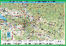
Directory on back side is extremely rich. Besides geographical informations about the mountain ridge, there are notes about mountain huts with free places for commemorative stamps. City-maps, schema of touristic routes and touristic directory as well as several photos and pictures make the back side colourfull and interesting. There is a map of Trzy Korony massif and Pieniny rafting in 1:15 000 scale too.